


Covadonga lacs invisibles

pidjam
User
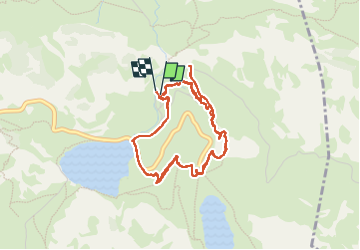

Length
6.6 km

Max alt
1150 m

Uphill gradient
240 m
Km-Effort
9.8 km

Min alt
1028 m

Downhill gradient
240 m
Boucle
Yes
Creation date :
2024-06-24 08:35:14.723
Updated on :
2024-06-24 14:12:26.663
2h01
Difficulty : Very easy

FREE GPS app for hiking
 SityTrail
IGN / Geographical institutes
SityTrail Plus
The world is yours!
About
Trail Walking of 6.6 km to be discovered at Asturias, Asturias, Cangas de Onís. This trail is proposed by pidjam.
Positioning
Country:
Spain
Region :
Asturias
Department/Province :
Asturias
Municipality :
Cangas de Onís
Location:
Unknown
Start:(Dec)
Start:(UTM)
338855 ; 4793448 (30T) N.
Comments